The bumper sticker for Big Bend Ranch
State Park reads “The Other Side of Nowhere” and that about
sums it up. It’s one of those places you really have to
want to go to. We took a trip to this state park in June and found it
to be one of the most unique and remote outdoor experiences Texas has
to offer.
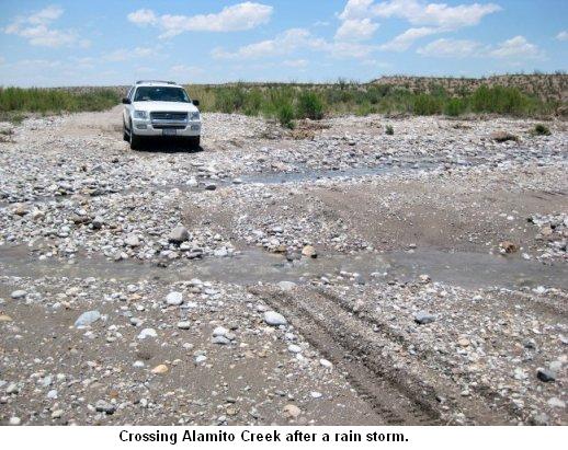
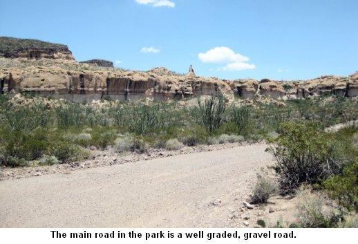 Head east on 170 out of Presidio or west from
Lajitas until you come to a brown sign that says “Big Bend Ranch
State Park” and Casa Piedra Road. Your adventure has already
begun … on a 27 mile gravel road … just to get to the
park headquarters. Although the brochure for the park indicates that
this main road is appropriate for 2 wheel drive vehicles, there’s
no way I would attempt it in a low slung “city” sedan. We
were driving a 2WD high clearance Ford Explorer and had no trouble on
this road. At least on the way in. More about that later. A low
riding car will have difficulty on this road as it is wash boarded in
several places, and there are a couple of low water crossings including
Alamito Creek shown here to negotiate. We managed about 15 miles per
hour over the 27 mile road just to get to the park headquarters.
So plan on approximately 1 ½ - two hours to make the trip.
Head east on 170 out of Presidio or west from
Lajitas until you come to a brown sign that says “Big Bend Ranch
State Park” and Casa Piedra Road. Your adventure has already
begun … on a 27 mile gravel road … just to get to the
park headquarters. Although the brochure for the park indicates that
this main road is appropriate for 2 wheel drive vehicles, there’s
no way I would attempt it in a low slung “city” sedan. We
were driving a 2WD high clearance Ford Explorer and had no trouble on
this road. At least on the way in. More about that later. A low
riding car will have difficulty on this road as it is wash boarded in
several places, and there are a couple of low water crossings including
Alamito Creek shown here to negotiate. We managed about 15 miles per
hour over the 27 mile road just to get to the park headquarters.
So plan on approximately 1 ½ - two hours to make the trip.
This is a remote camping experience. There are no services at the park whatsoever. No fuel, no groceries. Bring in everything you need, especially water, at least 5 gallons per person. There is a water spigot at Sauceda Ranch Headquarters for drinking water, but most of the campsites are a good distance away and you won’t want to be driving to the headquarters every time you need water. Bring empty containers to fill.
 You must pack out all trash.
There are no trash facilities or dumpsters anywhere in the park. Unless
you are staying at the headquarters (there is an air conditioned
bunkhouse with a men’s section and a woman’s section) or at
South Leyva where there is a composting toilet, you must pack out all
human waste using an RV style flushable system or disposable waste
bags. The headquarters does sell the Restop 2 disposable waste bags
(http://www.whennaturecalls.com).
You must pack out all trash.
There are no trash facilities or dumpsters anywhere in the park. Unless
you are staying at the headquarters (there is an air conditioned
bunkhouse with a men’s section and a woman’s section) or at
South Leyva where there is a composting toilet, you must pack out all
human waste using an RV style flushable system or disposable waste
bags. The headquarters does sell the Restop 2 disposable waste bags
(http://www.whennaturecalls.com).
There is virtually no cell service in the park at all. Occasionally, Alltell customers can get service at a location behind the headquarters building. We were using AT&T and had no service until we got within about ¼ mile of the main highway out of the park.
Despite the fact that there is no cell service in the park, you can get wireless internet at the bunkhouse at the park headquarters, and it works really well. There are plenty of electrical outlets to use in the bunkhouse and comfortable chairs to sit on. There is even wi-fi service on the porch of the bunkhouse where you can sit in these wonderful rustic rocking chairs to check your email. Campers as well as visitors staying in the bunkhouse are allowed to use these wireless facilities.

As we said before, there is no fuel in the park whatsoever. The nearest gas or diesel is in Presidio or Terlingua. FILL UP BEFORE YOU HEAD INTO THE PARK. You can use up a full tank in a hurry just driving from place to place in this vast park.
The main road in the park (from FM 170 to the headquarters at Sauceda and then another 7 miles to a point where the public access ends and the road deteriorates) is advertised as 2wd high clearance. But we would add that off-road or all terrain tires are an absolute necessity. Once you get off the main road, you will need 4 wheel drive high clearance and off road tires in most places. The roads are VERY rough with lots of ruts and there is evidence of vehicles scraping the rocks in many places. According to the ranger we talked to, when people call to make reservations they are asked what kind of vehicle they drive. Needless to say, RVs and motor homes are discouraged or “they leave here with a lot more rattles than they came.”
We stayed at the South Leyva Campsite, about a mile from the park headquarters at Sauceda. You get to the campsites via a one lane jeep track There are actually ten campsites with large picnic tables and bamboo and cedar arbors. It was over 90 degrees when we were there in June and that shade made all the difference for a pleasant stay. South Leyva also has a composting toilet so you don’t have to pack out your waste.
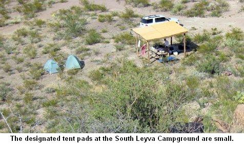
The tent pads are fairly small. Note that our tents are placed fairly close together as one of the requirements is that you only use the pads designated for tents. The pads are approximately 8 ft. x 8 ft. Supposedly, there is parking for two to three vehicles in most sites, but we had site number 7 and one car pretty much filled the parking space.
Los Ojitos – our favorite. One mile west of Sauceda. Very remote, not too far off the main road, on a hard, high clearance road. Parking for three cars, good and spacious tent pads. Currently no arbor or shelter, but good picnic table. Several excellent hiking trails from this site.
Papolitto Colorado – plenty of parking, good tent site, three cars, four tents, Recommend 2WD high clearance to get into the site.
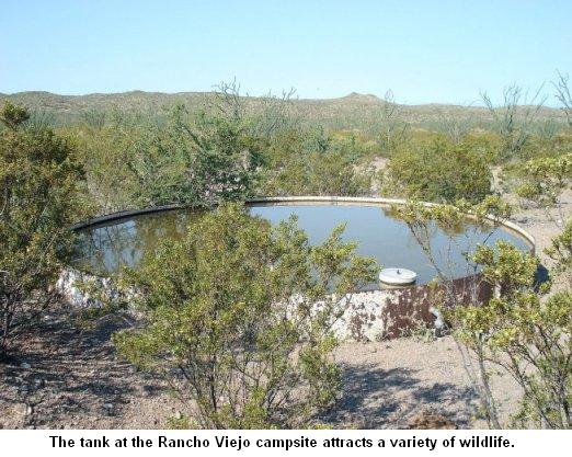 Rancho Viejo – Decent road
in, no shelter, a “rough site” with plenty of tent space
and parking, lots of shrubs and trees – thus it might be a haven
for flies and mosquitoes and other insects. The windmill and water tank
is certain to attract the wildlife of the desert. In addition, there is
historic debris all over the place. This is the site of what is thought
to be the first ranch in the area. The rock corral nearby was built
about 1930 by John Humphris. The parking area for a trailhead adjoins
the campsite, so there might be some traffic from other visitors.
Rancho Viejo – Decent road
in, no shelter, a “rough site” with plenty of tent space
and parking, lots of shrubs and trees – thus it might be a haven
for flies and mosquitoes and other insects. The windmill and water tank
is certain to attract the wildlife of the desert. In addition, there is
historic debris all over the place. This is the site of what is thought
to be the first ranch in the area. The rock corral nearby was built
about 1930 by John Humphris. The parking area for a trailhead adjoins
the campsite, so there might be some traffic from other visitors.
Vista de Bofecillas – high up a rough road. Definitely not a sedan road. Must have high clearance. No shelter. Top of mesa. Lots of parking. Lots of tent spots, but exposed.
For these “front country” campsites, you can easily explore parts of the park. Parking areas adjacent to trailheads provide access to day hikes that whet your appetite for explorations to more remote areas of the ranch.
Las Cuevas Amarillas area is located about 11 miles west of Sauceda Ranch. There are many small caves in the light colored rock formation that give the name to the area which means “the yellow caves.” The rock shelters show signs of human habitation dating back about 4,000 years.
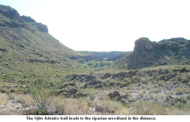 The Ojito Adentro Trail is
located about 8.5 miles west of Sauceda Ranch and it leads to a canyon
which gives the place its name “the little spring within.”
A desert woodland comprised of cottonwood, willow, hackberry and
mesquite trees is supported by a waterfall and a spring. Various
non-desert species live in this unique habitat in the desert. At times,
the trail may be closed due to occupation by threatened or endangered
species, so check with the rangers beforehand.
The Ojito Adentro Trail is
located about 8.5 miles west of Sauceda Ranch and it leads to a canyon
which gives the place its name “the little spring within.”
A desert woodland comprised of cottonwood, willow, hackberry and
mesquite trees is supported by a waterfall and a spring. Various
non-desert species live in this unique habitat in the desert. At times,
the trail may be closed due to occupation by threatened or endangered
species, so check with the rangers beforehand.
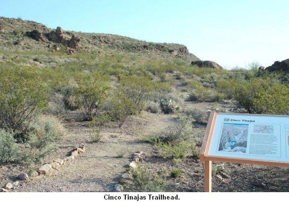
Life-giving water is often found in tinajas located in sheltered canyons of the desert. The Cinco Tinajas Trail, located about 1.3 miles west of Sauceda Ranch, leads down into a peaceful canyon where five small pools of water are water sources for the desert wildlife.
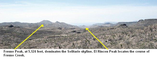
From the Pila Montoya Parking area, the old Marfa to Terlingua Road drops into Fresno Canyon and provides enchanting view of the Solitario, the foremost geologic feature of the park. Fresno Peak, the highest point of the Solitario at 5,124 feet, is clearly visible along the tilted ridges along the concentric circles of the eroded dome. The Fresno Canyon drainage has provided access to the Rio Grande for 5,000 years. A graded road built in the late 19th century follows a path that native Americans have used for centuries.
Although the park does not offer many conveniences, the staff goes out of its way to make visitors feel comfortable. According to the ranger, high season is November through January and spring break. He said that during spring break of 2009 the park’s campsites were nearly full.
The conveniences that the park does offer include restrooms at the park headquarters and limited shower facilities that are free and are open 24 hours. There is an ice machine at the headquarters, and it is paid for by donation. When we were there, the ice machine was out of service, but the kitchen staff at the bunkhouse generously provided us with ice. Once again, the roads from the campsites are rough and long so driving to the headquarters every time you need water or a shower is a challenge. Come prepared. The shower we use when we’re primitive camping uses about ½ gallon of water each per shower – and that includes shampooing and rinsing hair.
 A note of caution. As we said
earlier, we were driving a Ford Explorer which, unfortunately, did not
have off road or all terrain tires. On the way out of the park, and
within ¼ mile of the main road (FM 170), we had a flat. Not just
a flat – a totally ruined tire. The Fix-a-flat that the park
recommends you carry with you at all times just flowed right out the
hole. Evidently, we hit a sharp rock after the road had just been
graded and it not only put a hole in the tire, but broke the steel belt
as well. Fortunately, I had a good spare. We changed the tire, but had
to drive into Presidio to search for a spare. We still had a long way
to go to get back to Houston. Don’t expect to find a good
selection of tires in Presidio. In the end, we purchased a used and
patched tire that was close to the right size and would suffice in an
emergency. If you find yourself with a flat tire out in the BBRSP we
recommend Tom’s Texaco, if you need tire service. Norberto E.
Ocala, one of the owners, was extremely helpful. The cost to take off
wheel, put the spare back on the rim, and put the used tire on the
spare rim was $30. Not only that, we met a very helpful Border Patrol
agent as we were changing the tire who recommended Tom’s and also
gave us the phone numbers of the Border Patrol dispatch in that area,
in case we should we have more problems on the road.
A note of caution. As we said
earlier, we were driving a Ford Explorer which, unfortunately, did not
have off road or all terrain tires. On the way out of the park, and
within ¼ mile of the main road (FM 170), we had a flat. Not just
a flat – a totally ruined tire. The Fix-a-flat that the park
recommends you carry with you at all times just flowed right out the
hole. Evidently, we hit a sharp rock after the road had just been
graded and it not only put a hole in the tire, but broke the steel belt
as well. Fortunately, I had a good spare. We changed the tire, but had
to drive into Presidio to search for a spare. We still had a long way
to go to get back to Houston. Don’t expect to find a good
selection of tires in Presidio. In the end, we purchased a used and
patched tire that was close to the right size and would suffice in an
emergency. If you find yourself with a flat tire out in the BBRSP we
recommend Tom’s Texaco, if you need tire service. Norberto E.
Ocala, one of the owners, was extremely helpful. The cost to take off
wheel, put the spare back on the rim, and put the used tire on the
spare rim was $30. Not only that, we met a very helpful Border Patrol
agent as we were changing the tire who recommended Tom’s and also
gave us the phone numbers of the Border Patrol dispatch in that area,
in case we should we have more problems on the road.
Despite the remoteness of the area, the long slow tough drive into the park and the difficulty getting to some of the campsites, a visit to Big Bend Ranch State Park is well worth a visit. It offers some amazing hiking trails and spectacular vistas. We can’t wait to go back.
All in all, the Big Bend Ranch State Park offers a wide variety of camping, hiking and paddling experiences. And if you have any questions about our trip you can email Linda at lindagorski@cs.com or Louis at lfa@hal-pc.org
All material printed on
this
page
and this web site is copyrighted. All rights reserved.Head east on 170 out of Presidio or west from
Lajitas until you come to a brown sign that says “Big Bend Ranch
State Park” and Casa Piedra Road. Your adventure has already
begun … on a 27 mile gravel road … just to get to the
park headquarters. Although the brochure for the park indicates that
this main road is appropriate for 2 wheel drive vehicles, there’s
no way I would attempt it in a low slung “city” sedan. We
were driving a 2WD high clearance Ford Explorer and had no trouble on
this road. At least on the way in. More about that later. A low
riding car will have difficulty on this road as it is wash boarded in
several places, and there are a couple of low water crossings including
Alamito Creek shown here to negotiate. We managed about 15 miles per
hour over the 27 mile road just to get to the park headquarters.
So plan on approximately 1 ½ - two hours to make the trip.This is a remote camping experience. There are no services at the park whatsoever. No fuel, no groceries. Bring in everything you need, especially water, at least 5 gallons per person. There is a water spigot at Sauceda Ranch Headquarters for drinking water, but most of the campsites are a good distance away and you won’t want to be driving to the headquarters every time you need water. Bring empty containers to fill.
You must pack out all trash.
There are no trash facilities or dumpsters anywhere in the park. Unless
you are staying at the headquarters (there is an air conditioned
bunkhouse with a men’s section and a woman’s section) or at
South Leyva where there is a composting toilet, you must pack out all
human waste using an RV style flushable system or disposable waste
bags. The headquarters does sell the Restop 2 disposable waste bags
(http://www.whennaturecalls.com).There is virtually no cell service in the park at all. Occasionally, Alltell customers can get service at a location behind the headquarters building. We were using AT&T and had no service until we got within about ¼ mile of the main highway out of the park.
Despite the fact that there is no cell service in the park, you can get wireless internet at the bunkhouse at the park headquarters, and it works really well. There are plenty of electrical outlets to use in the bunkhouse and comfortable chairs to sit on. There is even wi-fi service on the porch of the bunkhouse where you can sit in these wonderful rustic rocking chairs to check your email. Campers as well as visitors staying in the bunkhouse are allowed to use these wireless facilities.
As we said before, there is no fuel in the park whatsoever. The nearest gas or diesel is in Presidio or Terlingua. FILL UP BEFORE YOU HEAD INTO THE PARK. You can use up a full tank in a hurry just driving from place to place in this vast park.
The main road in the park (from FM 170 to the headquarters at Sauceda and then another 7 miles to a point where the public access ends and the road deteriorates) is advertised as 2wd high clearance. But we would add that off-road or all terrain tires are an absolute necessity. Once you get off the main road, you will need 4 wheel drive high clearance and off road tires in most places. The roads are VERY rough with lots of ruts and there is evidence of vehicles scraping the rocks in many places. According to the ranger we talked to, when people call to make reservations they are asked what kind of vehicle they drive. Needless to say, RVs and motor homes are discouraged or “they leave here with a lot more rattles than they came.”
We stayed at the South Leyva Campsite, about a mile from the park headquarters at Sauceda. You get to the campsites via a one lane jeep track There are actually ten campsites with large picnic tables and bamboo and cedar arbors. It was over 90 degrees when we were there in June and that shade made all the difference for a pleasant stay. South Leyva also has a composting toilet so you don’t have to pack out your waste.
The tent pads are fairly small. Note that our tents are placed fairly close together as one of the requirements is that you only use the pads designated for tents. The pads are approximately 8 ft. x 8 ft. Supposedly, there is parking for two to three vehicles in most sites, but we had site number 7 and one car pretty much filled the parking space.
There are several campsites located
along the 27 mile road into the park headquarters. You can actually get
your camping permit at either Barton Warnock Center in Terlingua or at
Fort Leaton State Park, just east of Presidio, before you go into the
park, thus eliminating the need to go all the way to Sauceda before you
set up camp - if you choose to stay at a campsite on the way in. The
BBRSP website
(http://www.tpwd.state.tx.us/spdest/findadest/parks/big_bend_ranch/)
shows where these campsites are located. Some of the campsites we
explored are:
Los Ojitos – our favorite. One mile west of Sauceda. Very remote, not too far off the main road, on a hard, high clearance road. Parking for three cars, good and spacious tent pads. Currently no arbor or shelter, but good picnic table. Several excellent hiking trails from this site.
Papolitto Colorado – plenty of parking, good tent site, three cars, four tents, Recommend 2WD high clearance to get into the site.
Rancho Viejo – Decent road
in, no shelter, a “rough site” with plenty of tent space
and parking, lots of shrubs and trees – thus it might be a haven
for flies and mosquitoes and other insects. The windmill and water tank
is certain to attract the wildlife of the desert. In addition, there is
historic debris all over the place. This is the site of what is thought
to be the first ranch in the area. The rock corral nearby was built
about 1930 by John Humphris. The parking area for a trailhead adjoins
the campsite, so there might be some traffic from other visitors.Vista de Bofecillas – high up a rough road. Definitely not a sedan road. Must have high clearance. No shelter. Top of mesa. Lots of parking. Lots of tent spots, but exposed.
For these “front country” campsites, you can easily explore parts of the park. Parking areas adjacent to trailheads provide access to day hikes that whet your appetite for explorations to more remote areas of the ranch.
Las Cuevas Amarillas area is located about 11 miles west of Sauceda Ranch. There are many small caves in the light colored rock formation that give the name to the area which means “the yellow caves.” The rock shelters show signs of human habitation dating back about 4,000 years.
The Ojito Adentro Trail is
located about 8.5 miles west of Sauceda Ranch and it leads to a canyon
which gives the place its name “the little spring within.”
A desert woodland comprised of cottonwood, willow, hackberry and
mesquite trees is supported by a waterfall and a spring. Various
non-desert species live in this unique habitat in the desert. At times,
the trail may be closed due to occupation by threatened or endangered
species, so check with the rangers beforehand.Life-giving water is often found in tinajas located in sheltered canyons of the desert. The Cinco Tinajas Trail, located about 1.3 miles west of Sauceda Ranch, leads down into a peaceful canyon where five small pools of water are water sources for the desert wildlife.
From the Pila Montoya Parking area, the old Marfa to Terlingua Road drops into Fresno Canyon and provides enchanting view of the Solitario, the foremost geologic feature of the park. Fresno Peak, the highest point of the Solitario at 5,124 feet, is clearly visible along the tilted ridges along the concentric circles of the eroded dome. The Fresno Canyon drainage has provided access to the Rio Grande for 5,000 years. A graded road built in the late 19th century follows a path that native Americans have used for centuries.
Although the park does not offer many conveniences, the staff goes out of its way to make visitors feel comfortable. According to the ranger, high season is November through January and spring break. He said that during spring break of 2009 the park’s campsites were nearly full.
The conveniences that the park does offer include restrooms at the park headquarters and limited shower facilities that are free and are open 24 hours. There is an ice machine at the headquarters, and it is paid for by donation. When we were there, the ice machine was out of service, but the kitchen staff at the bunkhouse generously provided us with ice. Once again, the roads from the campsites are rough and long so driving to the headquarters every time you need water or a shower is a challenge. Come prepared. The shower we use when we’re primitive camping uses about ½ gallon of water each per shower – and that includes shampooing and rinsing hair.
A note of caution. As we said
earlier, we were driving a Ford Explorer which, unfortunately, did not
have off road or all terrain tires. On the way out of the park, and
within ¼ mile of the main road (FM 170), we had a flat. Not just
a flat – a totally ruined tire. The Fix-a-flat that the park
recommends you carry with you at all times just flowed right out the
hole. Evidently, we hit a sharp rock after the road had just been
graded and it not only put a hole in the tire, but broke the steel belt
as well. Fortunately, I had a good spare. We changed the tire, but had
to drive into Presidio to search for a spare. We still had a long way
to go to get back to Houston. Don’t expect to find a good
selection of tires in Presidio. In the end, we purchased a used and
patched tire that was close to the right size and would suffice in an
emergency. If you find yourself with a flat tire out in the BBRSP we
recommend Tom’s Texaco, if you need tire service. Norberto E.
Ocala, one of the owners, was extremely helpful. The cost to take off
wheel, put the spare back on the rim, and put the used tire on the
spare rim was $30. Not only that, we met a very helpful Border Patrol
agent as we were changing the tire who recommended Tom’s and also
gave us the phone numbers of the Border Patrol dispatch in that area,
in case we should we have more problems on the road.Despite the remoteness of the area, the long slow tough drive into the park and the difficulty getting to some of the campsites, a visit to Big Bend Ranch State Park is well worth a visit. It offers some amazing hiking trails and spectacular vistas. We can’t wait to go back.
All in all, the Big Bend Ranch State Park offers a wide variety of camping, hiking and paddling experiences. And if you have any questions about our trip you can email Linda at lindagorski@cs.com or Louis at lfa@hal-pc.org